Shiretoko, Hokkaido World Heritage Complete Guide|Thorough Explanation from Registration Reasons to Tourist Spots and Best Season
The Shiretoko Peninsula, which juts out into the Sea of Okhotsk in eastern Hokkaido, was registered as Japan’s 3rd Natural World Heritage site on July 17, 2005. It is highly evaluated as the southernmost location in the Northern Hemisphere where sea ice makes landfall, and for its unique ecosystem woven by sea and land. This article thoroughly explains Shiretoko’s appeal, from the reasons it was registered as a World Heritage site, to must-visit tourist spots, best seasons, and access methods.
What is Natural World Heritage?
World Heritage is a precious asset of humanity recognized by UNESCO (United Nations Educational, Scientific and Cultural Organization). There are three types of World Heritage: “Cultural Heritage,” “Natural Heritage,” and “Mixed Heritage,” with Shiretoko classified as Natural Heritage.
To be registered as a Natural World Heritage site, it must meet at least one of the following four evaluation criteria:
- Geology and Topography: Outstanding samples showing major stages of Earth’s history
- Ecosystems: Outstanding samples demonstrating significant ongoing ecological and biological processes in the evolution and development of terrestrial, freshwater, coastal, and marine ecosystems and their communities of flora and fauna
- Natural Landscapes: Areas of exceptional natural beauty and aesthetic importance featuring the highest natural phenomena or regions
- Biodiversity: Containing natural habitats most important and meaningful for the intrinsic conservation of biological diversity
Besides Shiretoko, Japan has five Natural World Heritage sites: Shirakami Mountains (registered 1993), Yakushima (registered 1993), Ogasawara Islands (registered 2011), and Amami Oshima, Tokunoshima, Northern Okinawa Island, and Iriomote Island (registered 2021).
Reasons for Shiretoko’s Registration as Natural World Heritage
Rich Marine Ecosystem Nurtured by Sea Ice
The greatest characteristic of the Shiretoko Peninsula is that it is located in a “seasonal sea ice zone” where seawater freezes at the lowest latitude in the Northern Hemisphere. In winter, sea ice drifts from the Sea of Okhotsk and covers the sea white.
This sea ice is not merely a block of ice. Large amounts of phytoplankton adhere to the bottom of the ice, and when the ice melts in spring, these plankton are released into the sea. Plankton becomes food for zooplankton, and the food chain continues to fish and marine mammals.
The nutrients carried by sea ice make the waters around Shiretoko one of the world’s most abundant fishing grounds. Abundant populations of salmonids such as salmon and trout, and marine mammals such as Steller sea lions and seals, live here, and the blessings of this sea have a major impact on terrestrial ecosystems.
Unique Ecosystem Connecting Sea and Land
Shiretoko was particularly highly evaluated as a Natural World Heritage site for the interconnection between marine and terrestrial ecosystems.
In autumn, numerous salmon return upstream to spawn in Shiretoko’s rivers. These salmon become an important food source for terrestrial animals such as brown bears, Blakiston’s fish owls, and white-tailed eagles. Brown bears catch salmon and carry some into the forest. The remains of uneaten salmon provide nutrients to forest soil, serving as fertilizer that creates rich forests.
In this way, nutrients grown in the sea are transported to land through salmon swimming upstream, enriching forests, and those forests return nutrients to the sea through rivers—the marine and terrestrial ecosystems circulate beautifully. This “connection between sea and land” is the greatest characteristic of Shiretoko’s ecosystem and is recognized worldwide as an extremely rare phenomenon.
Habitat for Rare Wildlife
Numerous globally rare wildlife species inhabit Shiretoko.
Blakiston’s Fish Owl is one of the world’s largest owls and is designated as Critically Endangered (Category IA) on the Ministry of the Environment’s Red List. In Japan, it inhabits only Hokkaido, with an estimated population of approximately 160 birds. Shiretoko is an important habitat for this species, and protection activities continue.
Brown Bears inhabit the entire Shiretoko Peninsula at high density, with a population density that ranks among the world’s highest. Shiretoko’s brown bears gather on coastal areas during salmon runs and shift their range seasonally, such as eating dwarf pine nuts in subalpine areas during summer.
Sika Deer also inhabit Shiretoko in large numbers and are important herbivores affecting forest vegetation. In recent years, population increases have become an issue, and management is conducted to maintain ecosystem balance.
Additionally, white-tailed eagles, Steller’s sea eagles, Shiretoko violet, and many other endemic or rare plants and animals have been confirmed, making it a treasure trove of biodiversity.
Highly Pristine Natural Environment
The Shiretoko Peninsula is characterized by steep, rugged terrain with mountains exceeding 1,000 meters in elevation descending to the coast with almost no flat land. This geographical condition restricts human activity and preserves primordial natural environments across a wide area.
The World Heritage registration area includes approximately 71,100 hectares of land from the central Shiretoko Peninsula to Shiretoko Cape and surrounding sea areas. More than 90% of the land area is state-owned forest, designated as a Shiretoko Forest Ecosystem Protection Zone and strictly protected.
Scope and Geography of Shiretoko Natural World Heritage
The Shiretoko Peninsula is located in northeastern Hokkaido and extends about 70 kilometers into the Sea of Okhotsk. Volcanic mountains including Mount Rausu (1,661 meters) and Mount Iou (1,562 meters) form a chain through the central peninsula, forming its backbone.
The World Heritage registration area includes the land from the central peninsula to Shiretoko Cape and surrounding sea areas (up to 3 kilometers offshore from the coastline). The land area is approximately 48,700 hectares, and the sea area is approximately 22,400 hectares.
Main Regions of Shiretoko Peninsula
Shari Town Side (Utoro District)
The western side of the peninsula facing the Sea of Okhotsk. Major tourist spots including Shiretoko Goko (Five Lakes), Kamui Wakka Waterfall, and Shiretoko Nature Center are concentrated here. The Utoro hot spring town offers abundant accommodations.
Rausu Town Side
The eastern side of the peninsula facing the Nemuro Strait. Known as a base for whale watching and bird watching, it is particularly popular in winter for observing sea ice and eagles. It is also a starting point for climbing Mount Rausu.
Shiretoko Yokodan Highway (National Route 334)
A full-length approximately 27-kilometer road connecting Utoro in Shari Town and Rausu Town, crossing Shiretoko Pass (738 meters elevation). From the pass, spectacular views of Mount Rausu and Kunashir Island spread out. It is closed to traffic in winter (approximately early November to late April).
Major Tourist Spots in Shiretoko
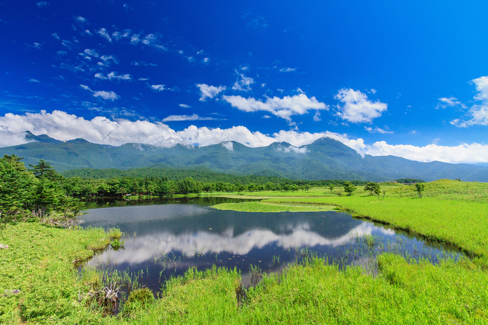
Shiretoko Goko (Five Lakes)
A signature tourist destination with five lakes surrounded by primeval forest. The sight of the Shiretoko mountain range reflected in the lake surface is breathtakingly beautiful.
Elevated Wooden Walkway (Free, No Reservation Required)
A barrier-free wooden path about 800 meters long that can be completed in approximately 40 minutes round trip to the viewpoint of the first lake. Electric fencing is installed for bear protection, allowing safe walks.
Ground Hiking Trail (Paid, Mandatory Pre-Lecture)
There is a large loop visiting all five lakes (about 3 kilometers, approximately 90 minutes) and a small loop visiting the second and first lakes (about 1.6 kilometers, approximately 40 minutes). During bear activity season (May 10 to July 31), participation in a guided tour with a registered guide is mandatory.
Kamui Wakka Waterfall
A waterfall where hot spring water from Mount Iou, an active volcano on the Shiretoko Peninsula, flows. The entire river is hot spring water, allowing visitors to enjoy a natural outdoor bath while climbing the waterfall.
Special non-slip shoes are required due to slippery conditions. Access is available only in summer; during the car restriction period (approximately early August to late September), shuttle bus use is necessary.
Shiretoko Pass
The highest point of the Shiretoko Yokodan Highway (738 meters elevation) offering spectacular views of Mount Rausu and distant Kunashir Island. On clear days, the mountains of Kunashir Island are clearly visible across the Nemuro Strait.
There are parking and restroom facilities, making it ideal for brief stops. Temperatures are more than 10 degrees lower than at sea level, so a jacket is necessary even in summer.
Freppe Waterfall (Maiden’s Waterfall)
A waterfall about 20 minutes’ walk from Shiretoko Nature Center along a hiking trail. Groundwater seeps from a crack in the cliff, appearing to flow like tears, hence the name “Maiden’s Waterfall.”
The trail is well-maintained, offering an approximately 2-kilometer round trip with easy trekking. The observation platform offers a panoramic view of the Sea of Okhotsk.
Shiretoko Cape
Located at the tip of the Shiretoko Peninsula, it cannot be reached by land. It is a remote location accessible only by ship cruise or multi-day mountaineering traverse for experienced climbers.
Shiretoko Cape cruises depart from Utoro Port, traveling toward Shiretoko Cape while observing cliffs, waterfalls, and wildlife. Encounters with brown bears, orcas, and dolphins are possible.
Rausu Lake
A secret lake on the eastern side of the Shiretoko Peninsula near Rausu Town. A full-scale trekking course about 3 kilometers one way with approximately 6 hours round trip.
The route progresses through primeval forest and passes several small marshes before reaching Rausu Lake. The silent lake is mystical, allowing visitors to experience Shiretoko’s pristine nature. It is bear habitat, so bear countermeasures are essential.
Oshinkosin Waterfall
Located along National Route 334, it is an easily accessible tourist spot just minutes from the parking area. The approximately 30-meter-wide waterfall splits into two streams, earning it the name “Twin Beauty Waterfall.”
Climbing the stairs allows visitors to reach the middle of the waterfall, and it is popular as a photo spot with the Sea of Okhotsk and Shiretoko mountains as backdrop.
Puyuni Cape
An observation spot between Utoro and toward Shiretoko Nature Center. It offers panoramic views of the Sea of Okhotsk, the town of Utoro, and the Shiretoko mountain range. It is particularly known as a sunset spot, with unparalleled beauty where the sun sets into the sea.
Activities You Can Experience in Shiretoko
Sea Ice Walk (Winter Only)
From late January to March, sea ice drifts ashore in the Sea of Okhotsk. Visitors can walk on sea ice and float in the sea ice while wearing dry suits.
Walking on sea ice is a truly otherworldly experience. With luck, seals resting on the ice can be encountered.
Whale Watching
The waters off Rausu in the Nemuro Strait are a sea area where sperm whales, orcas, and dolphins frequently appear. Encounter rates with sperm whales are particularly high in summer (May to October), allowing close observation of their impressive forms.
Orcas are observable in spring and early summer, while harbor porpoises and Dall’s porpoises can be observed year-round.
Bird Watching
Shiretoko is a treasure trove of wild birds. In winter, numerous Steller’s sea eagles and white-tailed eagles migrate and can be observed on sea ice and shorelines. In summer, forest birds such as Blakiston’s fish owls and black woodpeckers can be observed.
The Rausu Town side is particularly known worldwide as a premier location for winter eagle observation.
Trekking and Mountaineering
Shiretoko offers various trekking courses from beginner to advanced level.
- Beginner Level: Shiretoko Goko, Freppe Waterfall
- Intermediate Level: Shiretoko Nature Center to Shiretoko Bridge
- Advanced Level: Mount Rausu climbing, Rausu Lake trekking, Shiretoko Cape traverse
All courses pass through bear habitat, requiring thorough countermeasures such as carrying bear bells and hiking with multiple people.
Kayaking and SUP
Tours exploring Shiretoko’s seas and lakes by kayak or SUP (stand-up paddleboard) are also popular. The appeal includes cliffs and waterfalls visible only from the sea and encounters with wildlife.
Best Seasons to Visit Shiretoko
Shiretoko shows entirely different faces depending on the season, with appeal year-round.
Spring (April–May)
Snow melts and new greenery emerges. Sea ice may remain until late April. Bear activity becomes active, and sightings of mother bears with cubs occur. The opening of Shiretoko Yokodan Highway (late April) marks the arrival of spring.
Summer (June–August)
Peak tourism season. All major spots including Shiretoko Goko and Kamui Wakka Waterfall become fully accessible. Alpine flowers bloom magnificently, making it an ideal season for trekking. Long daylight hours with brightness until around 8 p.m. allow leisurely sightseeing. However, July–August see crowds, requiring advance reservations.
Autumn (September–October)
Autumn foliage season. The fall colors around Shiretoko Goko and Shiretoko Pass are magnificent, with peak viewing late September to early October. Salmon runs begin, and bears attracted to them can be observed. Fewer tourists allow quiet enjoyment of Shiretoko. Early snow may fall by late October.
Winter (November–March)
Sea ice season. From late January to March, sea ice whitens the Sea of Okhotsk. Winter-exclusive experiences include sea ice walks, sea ice cruises, and eagle observation. Shiretoko Yokodan Highway closes, limiting accessible spots, but winter Shiretoko offers mystical, special experiences.
Access Methods to Shiretoko
Access by Airplane
Via Memanbetsu Airport (Utoro Side)
- Direct flights from Tokyo (Haneda/Narita), Osaka (Itami/Kansai), and Nagoya (Chubu)
- Approximately 2 hours by car from Memanbetsu Airport to Shiretoko Utoro (approximately 90 kilometers)
- Airport shuttle bus and transfer to Utoro hot spring terminal bus possible
Via Nakashibetsu Airport (Rausu Side)
- Direct flights from Tokyo (Haneda) and Sapporo (New Chitose)
- Approximately 1 hour 40 minutes by car from Nakashibetsu Airport to Rausu (approximately 80 kilometers)
- Car rental convenient
JR and Bus Access
JR Senmo Line’s “Shiretoko-Shari Station” is the nearest station. From the station to Utoro takes approximately 50 minutes by bus. From Sapporo requires about 6 hours via limited express and regular trains.
Access by Car
From Sapporo
- Approximately 5 hours 30 minutes via Doto Expressway (approximately 400 kilometers)
- Winter requires caution for frozen road surfaces and blizzards
From Kushiro
- Approximately 3 hours via National Routes 391 and 244 (approximately 170 kilometers)
Precautions for Shiretoko Tourism
Bear Countermeasures
Shiretoko has extremely high brown bear population density. The following measures are essential for trekking and sightseeing:
- Carry bear bells and make noise while walking
- Travel in groups
- Avoid early morning and evening solo travel
- Turn back if bear signs (footprints, scat) are found
- Be mindful of food odors
- Consider carrying bear spray
Clothing and Equipment
Shiretoko weather changes easily, and temperatures are low even in summer.
- Layered clothing
- Waterproof and windproof jacket
- Trekking shoes (non-slip soles)
- Hat and sunglasses
- Insect repellent spray (summer)
- Drinking water and snacks
Environmental Conservation Rules
To preserve the World Heritage site of Shiretoko for future generations, observe these rules:
- Always take garbage home
- Do not collect plants
- Do not feed animals
- Stay on designated paths
- Do not approach wildlife too closely
- Avoid loud voices
Accommodations Near Shiretoko
Utoro Hot Spring
Serves as the base for Shiretoko tourism. Many hot spring inns overlooking the Sea of Okhotsk offer fresh seafood cuisine.
Various accommodations from large hotels to family-run inns are available. Advance reservations are recommended as summer and sea ice seasons are crowded.
Rausu Hot Spring
A hot spring resort on the eastern Shiretoko Peninsula in Rausu Town. Convenient as a base for whale watching and bird watching.
Iwao Betsu Hot Spring
A secret hot spring in Shiretoko’s mountains known as “Lamp House.” With no electricity, night is spent by lamplight, offering a special experience. Used as a pre-climbing base camp for Mount Rausu.
Ministry of the Environment and Forestry Agency Initiatives in Shiretoko
Various efforts are undertaken with the Ministry of the Environment and Forestry Agency at the center to preserve Shiretoko’s natural environment.
Shiretoko World Heritage Center (Utoro)
Operated by the Ministry of the Environment, this facility allows learning about Shiretoko’s nature and its value as a World Heritage site. Latest bear activity information and trail conditions can be confirmed, making a pre-sightseeing visit recommended.
Shiretoko Forest Ecosystem Protection Zone
Managed by Hokkaido Forest Management Bureau as state-owned forest, comprising over 90% of the World Heritage land area. Strict management maintains and conserves the pristine forest environment.
Sika Deer Management
To suppress vegetation impacts from increasing sika deer, scientifically-based population management is implemented.
Sea Area Management
Marine ecosystem conservation in waters around Shiretoko is advanced while seeking coexistence with fishing. Salmon and trout resource management and marine mammal protection activities are conducted.
Shiretoko’s Symbol Mark and Message
Shiretoko Natural World Heritage has an official symbol mark expressing the connection between sea and land and the rich ecosystem brought by sea ice.
Under the message “Know Shiretoko, Protect Shiretoko, Pass Shiretoko to Future Generations,” efforts to protect Shiretoko’s nature continue with local residents, tourists, and government working together.
Summary: The Value and Appeal of Shiretoko Natural World Heritage
Hokkaido’s Shiretoko possesses a worldly rare natural environment where the marine ecosystem nurtured by sea ice and the primordial terrestrial ecosystem beautifully interconnect. Since its Natural World Heritage registration in 2005, many domestic and international visitors have been moved by its magnificent nature.
The serene beauty of Shiretoko Goko, the rustic hot spring charm of Kamui Wakka Waterfall, the grand panorama from Shiretoko Pass, winter’s Sea of Okhotsk covered in sea ice, and encounters with rare wildlife such as brown bears and Blakiston’s fish owls. Shiretoko offers special natural experiences impossible to encounter in other regions of Japan.
To pass this precious World Heritage asset to future generations, each visitor must observe environmental conservation rules and respect Shiretoko’s nature.
When visiting Shiretoko, prepare adequately with sufficient knowledge, exercise safety precautions, and fully savor this miraculous nature. It will surely become an unforgettable memory.